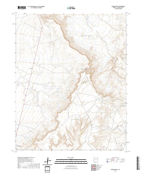
2021 Map of Ganado Mesa
USGS Topo · Published 2021About this map
Beautiful Valley dominates the northern reaches of this Arizona landscape, a broad expanse of high desert terrain characterized by seasonal watercourses and prominent landforms. The topography is anchored by the massive Ganado Mesa, which rises in the south and dictates the local drainage patterns. To its west lies the settlement of Burnside, positioned at a junction of regional transit routes near the natural water source of Snake Springs. The map details the intricate network of washes that define the area's hydrology, including the northern Bi Keesh Wash and the more eastern Bis It Ah Wash. Local infrastructure is marked by tribal routes such as Indian Rte 27 and backcountry roads like Co Rd 458, which traverse the open stretches of Snake Flat.
Find a feature on this map
19 named features on this map. Tap any name to fly to it.
Don’t see what you’re looking for? This feature index may not catch every label — zoom into the map to look around manually.
Map Details
Editions of this 2021 Ganado Mesa Map
This is the sole edition of this map. No revisions or reprints were ever made.
Other maps of this area

1886 · Fort Defiance
USGS Topo · 1:250,000

1892 · Fort Defiance
USGS Topo · 1:250,000

1954 · Gallup
USGS Topo · 1:250,000

1955 · Zith-Tusayan Butte 3 NW
USGS Topo · 1:24,000

1955 · Zith-Tusayan Butte 2 SW
USGS Topo · 1:24,000

1955 · Zith-Tusayan Butte 2 NW
USGS Topo · 1:24,000
1955 · Nazlini
USGS Topo · 1:62,500
1955 · Ganado 1 NE
USGS Topo · 1:24,000

1958 · Gallup
USGS Topo · 1:250,000

1959 · Gallup
USGS Topo · 1:250,000