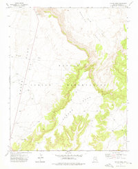
1972 Map of Ganado Mesa
USGS Topo · Published 1976About this map
Ganado Mesa dominates the landscape of the Navajo Indian Reservation in the early 1970s, characterized by its sharp escarpments and plateau terrain. The region is defined by significant hydrologic and geographic markers like Bis Ii Ah Wash and Bi Keesh Wash, which carve through the Beautiful Valley. To the west, the expansive Snake Flat is punctuated by Snake Springs and several Borrow Pits, indicating localized resource extraction or road construction activity during this era.
Find a feature on this map
12 named features on this map. Tap any name to fly to it.
Don’t see what you’re looking for? This feature index may not catch every label — zoom into the map to look around manually.
Map Details
Editions of this 1972 Ganado Mesa Map
This is the sole edition of this map. No revisions or reprints were ever made.
Other maps of this area

1886 · Fort Defiance
USGS Topo · 1:250,000

1892 · Fort Defiance
USGS Topo · 1:250,000

1954 · Gallup
USGS Topo · 1:250,000

1955 · Zith-Tusayan Butte 3 NW
USGS Topo · 1:24,000

1955 · Zith-Tusayan Butte 2 SW
USGS Topo · 1:24,000

1955 · Zith-Tusayan Butte 2 NW
USGS Topo · 1:24,000
1955 · Nazlini
USGS Topo · 1:62,500
1955 · Ganado 1 NE
USGS Topo · 1:24,000

1958 · Gallup
USGS Topo · 1:250,000

1959 · Gallup
USGS Topo · 1:250,000