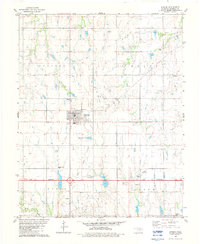
1982 Map of Garber
USGS Topo · Published 1983About this map
The town of Garber serves as the central hub of this Garfield County landscape, which by the early 1980s was defined by its extensive Oil and Gas Field operations. This energy-producing infrastructure is woven into the rural fabric of the Allison and Grant townships, where active and old well sites sit alongside essential local landmarks like the Water Tank and electrical Substation.
Find a feature on this map
19 named features on this map. Tap any name to fly to it.
Don’t see what you’re looking for? This feature index may not catch every label — zoom into the map to look around manually.
Map Details
Editions of this 1982 Garber Map
This is the sole edition of this map. No revisions or reprints were ever made.
Other maps of this area

1955 · Enid
USGS Topo · 1:250,000

1956 · Garber
USGS Topo · 1:62,500

1958 · Enid
USGS Topo · 1:250,000

1968 · Lamont SE
USGS Topo · 1:24,000

1968 · Billings
USGS Topo · 1:24,000

1968 · Hunter
USGS Topo · 1:24,000

1972 · Perry NW
USGS Topo · 1:24,000

1972 · Lucien
USGS Topo · 1:24,000
1979 · Perry NW
USGS Topo · 1:24,000
1982 · Breckinridge
USGS Topo · 1:24,000