
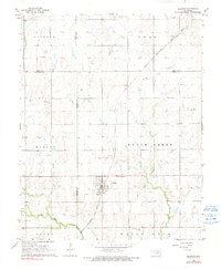
1968 Map of Billings
USGS Topo · Published 1969About this map
Billings serves as the central hub of this late-1960s agricultural and energy landscape, situated at the intersection of four counties: Garfield, Noble, Kay, and Grant. The town is oriented around the Chicago Rock Island and Pacific railroad, which cuts diagonally across the northern townships toward the small settlement of Alcorn. The surrounding terrain is defined by a series of north-south drainage systems, including Bunch Creek and Ranch Creek, which feed into the larger Red Rock Creek along the southern border. This period of development is marked by a clear economic reliance on natural resources, evidenced by numerous Oil Wells and a Shale Pit scattered throughout the rural sections. Genealogists will find particular value in the detailed locations of local burial grounds, such as Sacred Heart Cem just north of the city limits and Billings Union Cem to the south.
Find a feature on this map
29 named features on this map. Tap any name to fly to it.
Don’t see what you’re looking for? This feature index may not catch every label — zoom into the map to look around manually.
Map Details
Editions of this 1968 Billings Map
2 editions found
Other maps of this area

1955 · Enid
USGS Topo · 1:250,000

1956 · Garber
USGS Topo · 1:62,500

1958 · Enid
USGS Topo · 1:250,000

1968 · Lamont SE
USGS Topo · 1:24,000

1968 · Tonkawa SE
USGS Topo · 1:24,000

1968 · Eddy
USGS Topo · 1:24,000

1968 · Tonkawa
USGS Topo · 1:24,000

1968 · Lamont
USGS Topo · 1:24,000

1972 · Perry NW
USGS Topo · 1:24,000

1972 · Ceres
USGS Topo · 1:24,000