
1972 Map of Ceres
USGS Topo · Published 1974About this map
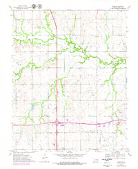
Red Rock Creek meanders across the central landscape of this Noble County survey, defining the agricultural character of the region in the early 1970s. The small community of Ceres sits north of the creek, while the southern portion of the map is dominated by the modern infrastructure of the Cimarron Turnpike and the Enid Interchange. Evidence of the area's cultural heritage is visible through sites like the Bohemian Hall and Bohemian Cem, alongside Mt Carmel Cem.
Find a feature on this map
21 named features on this map. Tap any name to fly to it.
Don’t see what you’re looking for? This feature index may not catch every label — zoom into the map to look around manually.
Map Details
Editions of this 1972 Ceres Map
2 editions found
Other maps of this area

1955 · Enid
USGS Topo · 1:250,000

1958 · Enid
USGS Topo · 1:250,000

1968 · Billings
USGS Topo · 1:24,000

1968 · Tonkawa SE
USGS Topo · 1:24,000

1968 · Marland
USGS Topo · 1:24,000

1972 · Perry NW
USGS Topo · 1:24,000

1972 · Red Rock
USGS Topo · 1:24,000

1972 · Perry
USGS Topo · 1:24,000

1972 · Lucien
USGS Topo · 1:24,000
1972 · Black Bear
USGS Topo · 1:24,000