
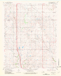
1968 Map of Tonkawa SE
USGS Topo · Published 1969About this map
The Three Sands Oil Field dominates this late-1960s landscape, illustrating the intensive petroleum extraction industry along the Kay and Noble county line. This survey, based on 1965 aerial photography and field-checked in 1968, documents a rural terrain transitioning toward modern infrastructure, centered on the Okla 15 Interchange and the expanding 4 Lane highway system. While energy production is the primary driver of activity here, older rural foundations remain visible in small communities like Owen and Glenrose.
Find a feature on this map
28 named features on this map. Tap any name to fly to it.
Don’t see what you’re looking for? This feature index may not catch every label — zoom into the map to look around manually.
Map Details
Editions of this 1968 Tonkawa SE Map
2 editions found
Other maps of this area

1955 · Enid
USGS Topo · 1:250,000

1958 · Enid
USGS Topo · 1:250,000

1968 · Billings
USGS Topo · 1:24,000

1968 · Marland
USGS Topo · 1:24,000

1968 · Ponca City NW
USGS Topo · 1:24,000

1968 · Eddy
USGS Topo · 1:24,000

1968 · Tonkawa
USGS Topo · 1:24,000

1972 · Perry NW
USGS Topo · 1:24,000

1972 · Red Rock
USGS Topo · 1:24,000

1972 · Ceres
USGS Topo · 1:24,000