
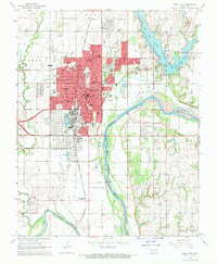
1968 Map of Ponca City SE
USGS Topo · Published 1969About this map
White Eagle and the surrounding river bottomlands characterize this late 1960s landscape where the Salt Fork Arkansas River joins the main Arkansas River channel. The area's transport and industrial footprint is defined by the Atchison Topeka and Santa Fe railroad line running through the northwestern section and numerous Oil Wells scattered across the uplands. Settlement patterns are concentrated in smaller communities like West Bressie, East Bressie, and Otoe to the south. The terrain transitions from the broad alluvial plains of Miller to the more prominent elevations of Big Hill in the east. This survey captures a moment of active resource extraction, evidenced by several Quarries and water management features like the Flowing Well and Water Tank near the river junction.
Find a feature on this map
23 named features on this map. Tap any name to fly to it.
Don’t see what you’re looking for? This feature index may not catch every label — zoom into the map to look around manually.
Map Details
Editions of this 1968 Ponca City SE Map
This is the sole edition of this map. No revisions or reprints were ever made.
Other maps of this area

1930 · Pawnee
USGS Topo · 1:62,500

1936 · Belford
USGS Topo · 1:62,500

1936 · Pawnee
USGS Topo · 1:62,500

1955 · Enid
USGS Topo · 1:250,000

1958 · Enid
USGS Topo · 1:250,000

1963 · Charley Creek
USGS Topo · 1:24,000

1968 · Marland
USGS Topo · 1:24,000

1968 · Ponca City NW
USGS Topo · 1:24,000
1968 · Ponca City
USGS Topo · 1:24,000

1972 · Morrison NE
USGS Topo · 1:24,000