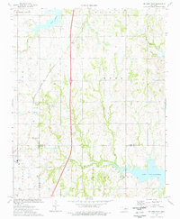
1974 Map of Orlando East
USGS Topo · Published 1977About this map
Orlando serves as the primary settlement on this 1974 survey, situated at the junction of Logan and Noble counties. The landscape is defined by the heavy infrastructure of the energy and transport sectors in the mid-1970s, with extensive Oil Fields and numerous Oil Wells peppered across the townships. The Atchison Topeka and Santa Fe railroad cuts a diagonal path through the western half of the sheet, while the northern and eastern reaches are anchored by significant water bodies, including Lake Perry and the sprawling western edge of Lake Carl Blackwell. Local heritage is marked by sites like Fairview Cem and the distinctive topography of Warren Valley. The presence of several Drill Holes and a Gravel Pit alongside the various creek systems suggests a region deeply engaged in natural resource extraction and land management during this era.
Find a feature on this map
29 named features on this map. Tap any name to fly to it.
Don’t see what you’re looking for? This feature index may not catch every label — zoom into the map to look around manually.
Map Details
Editions of this 1974 Orlando East Map
This is the sole edition of this map. No revisions or reprints were ever made.
Other maps of this area

1893 · Mulhall
USGS Topo · 1:62,500

1893 · Stillwater
USGS Topo · 1:62,500

1955 · Enid
USGS Topo · 1:250,000

1958 · Enid
USGS Topo · 1:250,000

1966 · Lake Carl Blackwell
USGS Topo · 1:24,000
1967 · Stillwater SW
USGS Topo · 1:24,000

1972 · Perry
USGS Topo · 1:24,000

1972 · Lucien
USGS Topo · 1:24,000
1972 · Black Bear
USGS Topo · 1:24,000
1974 · Mulhall
USGS Topo · 1:24,000