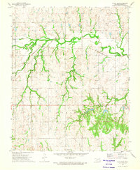
1972 Map of Black Bear
USGS Topo · Published 1974About this map
Black Bear Creek meanders through this landscape in Noble County, marking a terrain defined by both its natural drainage and early 1970s industrial activity. The convergence of the Atchison Topeka and Santa Fe and the St Louis-San Francisco railroads highlights the area's importance as a transportation corridor during this era. Scattered across the rural sections are signs of local industry and community life, from multiple oil wells and shale pits to the isolated Water Tank. Genealogists will find particular value in the presence of Zion Ch and its adjacent Zion Cem, alongside the Richburg Cem further south. The map also documents the transition of land use near the Black Bear Meridian, showing a mix of established watercourses like Elm Creek and emerging developments such as a Trailer Park.
Find a feature on this map
22 named features on this map. Tap any name to fly to it.
Don’t see what you’re looking for? This feature index may not catch every label — zoom into the map to look around manually.
Map Details
Editions of this 1972 Black Bear Map
2 editions found
Other maps of this area

1893 · Mulhall
USGS Topo · 1:62,500

1893 · Stillwater
USGS Topo · 1:62,500

1955 · Enid
USGS Topo · 1:250,000

1958 · Enid
USGS Topo · 1:250,000

1966 · Lake Carl Blackwell
USGS Topo · 1:24,000
1967 · Stillwater North
USGS Topo · 1:24,000

1972 · Morrison NE
USGS Topo · 1:24,000

1972 · Morrison
USGS Topo · 1:24,000

1972 · Red Rock
USGS Topo · 1:24,000

1972 · Ceres
USGS Topo · 1:24,000