
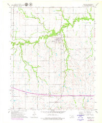
1972 Map of Red Rock
USGS Topo · Published 1974About this map
The town of Red Rock (Redrock PO) serves as a focal point in this Noble County landscape, situated where the Atchison Topeka and Santa Fe railroad crosses the winding path of Red Rock Creek. The 1970s infrastructure reflects a period of transition, with the Cimarron Turnpike shown under construction across the southern portion of the sheet. This new highway cuts through established energy sectors including a significant Gas Field and an Oil Field, highlighting the region's industrial reliance on subsurface resources.
Find a feature on this map
25 named features on this map. Tap any name to fly to it.
Don’t see what you’re looking for? This feature index may not catch every label — zoom into the map to look around manually.
Map Details
Editions of this 1972 Red Rock Map
2 editions found
Other maps of this area

1955 · Enid
USGS Topo · 1:250,000

1958 · Enid
USGS Topo · 1:250,000

1968 · Tonkawa SE
USGS Topo · 1:24,000

1968 · Marland
USGS Topo · 1:24,000

1968 · Ponca City SE
USGS Topo · 1:24,000

1972 · Morrison NE
USGS Topo · 1:24,000

1972 · Morrison
USGS Topo · 1:24,000

1972 · Ceres
USGS Topo · 1:24,000

1972 · Perry
USGS Topo · 1:24,000
1972 · Black Bear
USGS Topo · 1:24,000