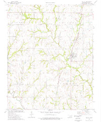
1974 Map of Mulhall
USGS Topo · Published 1977About this map
Mulhall stands as the central hub of this Oklahoma landscape, defined by the prominent Atchison Topeka and Santa Fe railroad corridor. The town's grid is neighbored by the Roselawn Cem, while the surrounding terrain is marked by significant topographical rises like Rose Hill and Mulhall hill. The mapping reveals a detailed network of petroleum exploration, with numerous Oil Wells and a Drill Hole scattered across the township lines, particularly in the northern reaches of Lebron and Orlando. Drainage systems are well-documented, showing the convergence of West Beaver Creek and Middle Bruner Creek into the main Beaver Creek channel, while Skeleton Creek cuts through the southwestern corner. Historical infrastructure is visible in the form of an Old Railroad Grade and a Radio Tower, providing clear markers for local history research.
Find a feature on this map
19 named features on this map. Tap any name to fly to it.
Don’t see what you’re looking for? This feature index may not catch every label — zoom into the map to look around manually.
Map Details
Editions of this 1974 Mulhall Map
This is the sole edition of this map. No revisions or reprints were ever made.
Other maps of this area

1892 · Guthrie
USGS Topo · 1:62,500

1892 · Kingfisher
USGS Topo · 1:125,000

1893 · Mulhall
USGS Topo · 1:62,500

1893 · Lovell
USGS Topo · 1:62,500

1895 · Kingfisher
USGS Topo · 1:125,000

1954 · Oklahoma City
USGS Topo · 1:250,000

1955 · Enid
USGS Topo · 1:250,000

1957 · Oklahoma City
USGS Topo · 1:250,000

1958 · Enid
USGS Topo · 1:250,000

1963 · Oklahoma City
USGS Topo · 1:250,000