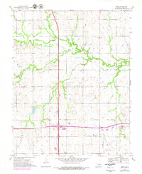
1972 Map of Ceres
USGS Topo · Published 1979About this map
Red Rock Creek meanders through the central landscape of this Oklahoma survey, defining the agrarian and industrial character of Noble County during the early 1970s. The settlement of Ceres sits north of the creek, while the southern portion of the map is dominated by the Cimarron Turnpike and its connection at the Enid Interchange. The region shows significant fossil fuel activity, marked by numerous oil wells and several shale pits scattered across the terrain. Cultural landmarks such as Bohemian Hall and the nearby Bohemian Cem reflect the local heritage of the area, while the Perry Municipal Airport occupies the southeast corner, providing a glimpse into the infrastructure of the era. The mapping of Mt Carmel Cem and various rural school sections offers valuable detail for genealogists tracing family histories in this part of the southern plains.
Find a feature on this map
20 named features on this map. Tap any name to fly to it.
Don’t see what you’re looking for? This feature index may not catch every label — zoom into the map to look around manually.
Map Details
Editions of this 1972 Ceres Map
2 editions found
Other maps of this area

1955 · Enid
USGS Topo · 1:250,000

1958 · Enid
USGS Topo · 1:250,000

1968 · Billings
USGS Topo · 1:24,000

1968 · Tonkawa SE
USGS Topo · 1:24,000

1968 · Marland
USGS Topo · 1:24,000

1972 · Perry NW
USGS Topo · 1:24,000

1972 · Red Rock
USGS Topo · 1:24,000

1972 · Ceres
USGS Topo · 1:24,000

1972 · Perry
USGS Topo · 1:24,000

1972 · Lucien
USGS Topo · 1:24,000