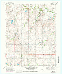
1972 Map of Perry NW
USGS Topo · Published 1985About this map
Red Rock Creek and Sandy Bunch Creek meander through the northern reaches of this Noble County landscape, defining a terrain shaped by both water and industry during the early 1970s. The area sits at the intersection of agricultural tradition and energy extraction, evidenced by the broad Gas Field and numerous scattered Oil Wells and Oil Well sites. The Garfield Co Noble Co boundary line divides the western portion of the map, where the Chicago Rock Island and Pacific railroad cuts a diagonal path across the corner. Local history is anchored by essential community landmarks like the Antelope Valley Sch and Polo Cem. From the elevated terrain at White Rock down to the banks of Elkhorn Creek, the map captures a rural Oklahoma district balancing its natural drainage systems with the infrastructure of mid-century petroleum development.
Find a feature on this map
20 named features on this map. Tap any name to fly to it.
Don’t see what you’re looking for? This feature index may not catch every label — zoom into the map to look around manually.
Map Details
Editions of this 1972 Perry NW Map
3 editions found
Other maps of this area

1955 · Enid
USGS Topo · 1:250,000

1956 · Garber
USGS Topo · 1:62,500

1958 · Enid
USGS Topo · 1:250,000

1968 · Lamont SE
USGS Topo · 1:24,000

1968 · Billings
USGS Topo · 1:24,000

1968 · Tonkawa SE
USGS Topo · 1:24,000

1972 · Perry NW
USGS Topo · 1:24,000

1972 · Ceres
USGS Topo · 1:24,000

1972 · Perry
USGS Topo · 1:24,000

1972 · Lucien
USGS Topo · 1:24,000