
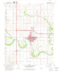
1968 Map of Tonkawa
USGS Topo · Published 1970About this map
The Salt Fork Arkansas River and Chikaskia River converge just south of Tonkawa, framing a landscape defined by hydraulic energy and petroleum extraction. This late 1960s survey documents the town at a moment of educational and industrial significance, featuring the campus of Northern Oklahoma Jr College and several local schools like Lincoln Sch and Washington Sch. The surrounding territory is heavily shaped by the energy sector, with the Hubbard Oil Field, Tonkawa Oil Field, and West Autwine Oil Field signaling the regional economic driver of the era. Transportation networks are robust, showing the Atchison Topeka and Santa Fe and Chicago Rock Island and Pacific railroads alongside modern infrastructure like the US 60 Interchange. Local genealogists will find value in the placement of the IOOF Cem and Tonkawa Cem, which serve the local community and the nearby settlement of Tyner.
Find a feature on this map
36 named features on this map. Tap any name to fly to it.
Don’t see what you’re looking for? This feature index may not catch every label — zoom into the map to look around manually.
Map Details
Editions of this 1968 Tonkawa Map
2 editions found
Other maps of this area

1955 · Enid
USGS Topo · 1:250,000

1958 · Enid
USGS Topo · 1:250,000

1968 · Billings
USGS Topo · 1:24,000

1968 · Tonkawa SE
USGS Topo · 1:24,000

1968 · Marland
USGS Topo · 1:24,000

1968 · Ponca City NW
USGS Topo · 1:24,000

1968 · Eddy
USGS Topo · 1:24,000

1968 · Nardin
USGS Topo · 1:24,000

1968 · Blackwell
USGS Topo · 1:24,000
1968 · Newkirk SW
USGS Topo · 1:24,000