
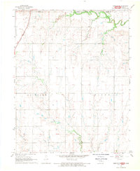
1968 Map of Nardin
USGS Topo · Published 1970About this map
Agricultural prairie and petroleum industry define this landscape along the border of Grant and Kay counties. The settlement of Nardin sits at the heart of the quadrangle, serving as a hub for the Atchison Topeka and Santa Fe railroad line. Industrial infrastructure is prominent, notably within the Deer Creek Oil Field and a significant Gas Storage Area in the northern reaches. These energy resources are juxtaposed against the natural drainage patterns of Doe Creek and Big Antelope Cr. To the south, the St Louis and San Francisco railroad cuts through the terrain near Lamont and Carlisle. Local history is anchored by sites like Mt Oliver Cem, providing a clear view of the mid-century rural Oklahoma economy where rail transport, ranching, and oil extraction intersected.
Find a feature on this map
24 named features on this map. Tap any name to fly to it.
Don’t see what you’re looking for? This feature index may not catch every label — zoom into the map to look around manually.
Map Details
Editions of this 1968 Nardin Map
This is the sole edition of this map. No revisions or reprints were ever made.
Other maps of this area

1955 · Enid
USGS Topo · 1:250,000

1958 · Enid
USGS Topo · 1:250,000

1967 · Braman
USGS Topo · 1:24,000

1968 · Deer Creek
USGS Topo · 1:24,000

1968 · Eddy
USGS Topo · 1:24,000

1968 · Blackwell NW
USGS Topo · 1:24,000

1968 · Tonkawa
USGS Topo · 1:24,000

1968 · Lamont
USGS Topo · 1:24,000
1968 · Medford NE
USGS Topo · 1:24,000

1968 · Blackwell
USGS Topo · 1:24,000