
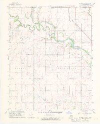
1968 Map of Blackwell NW
USGS Topo · Published 1970About this map
The Chikaskia River snakes across the Oklahoma-Kansas border in this late 1960s survey, defining the rural character of northern Kay County. Near the state line, the town of Hunnewell sits adjacent to the Atchison Topeka and Santa Fe railroad, which cuts a sharp diagonal through the prairie landscape. The area is marked by a blend of agricultural and industrial signatures, from the Triumph Cem and Asbury Ch to active resource extraction at the Webb North Oil Field and scattered Oil Wells. Significant water features like Lake Blackwell and the rocky stretches of Rock Falls contrast with the numerous meandering tributaries such as Bluff Creek, Sand Creek, and Doe Creek. This map captures a specific moment in the region's development, documenting localized landmarks like the Camp of the Cross and the Fox Landing Strip used by local aviators.
Find a feature on this map
20 named features on this map. Tap any name to fly to it.
Don’t see what you’re looking for? This feature index may not catch every label — zoom into the map to look around manually.
Map Details
Editions of this 1968 Blackwell NW Map
2 editions found
Other maps of this area

1889 · Caldwell
USGS Topo · 1:125,000

1890 · Wellington
USGS Topo · 1:125,000

1893 · Caldwell
USGS Topo · 1:125,000

1897 · Caldwell
USGS Topo · 1:125,000

1955 · Wichita
USGS Topo · 1:250,000

1955 · Enid
USGS Topo · 1:250,000

1958 · Enid
USGS Topo · 1:250,000

1958 · Wichita
USGS Topo · 1:250,000

1965 · Portland
USGS Topo · 1:24,000

1965 · South Haven
USGS Topo · 1:24,000