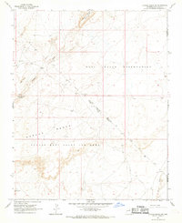
1967 Map of Garces Mesas NE
USGS Topo · Published 1969About this map
Hopi Indian Reservation lands dominate this high desert landscape during the late 1960s, a period marked by complex jurisdictional boundaries. The sheet documents the Navajo-Hopi Joint Use Area, illustrating the overlapping territories and shared administrative zones of the era. The terrain is defined by the massive uplift of Padilla Mesa and Garces Mesas, which rise above the surrounding drainage networks. Reliable water sources appear as critical infrastructure in this arid environment, noted by the presence of the Sweet Water Well, Redrock Spring Well, and the Salt Well. Seasonal hydrological patterns are visible in the paths of Oraibi Wash and Saltwater Wash, while a lone Corral and a network of Sand Dunes near Spring suggest the traditional pastoral use of the plateau.
Find a feature on this map
17 named features on this map. Tap any name to fly to it.
Don’t see what you’re looking for? This feature index may not catch every label — zoom into the map to look around manually.
Map Details
Editions of this 1967 Garces Mesas NE Map
This is the sole edition of this map. No revisions or reprints were ever made.
Other maps of this area

1883 · Tusayan
USGS Topo · 1:250,000

1886 · Tusayan
USGS Topo · 1:250,000

1947 · Flagstaff
USGS Topo · 1:250,000

1954 · Flagstaff
USGS Topo · 1:250,000

1958 · Flagstaff
USGS Topo · 1:250,000

1960 · Flagstaff
USGS Topo · 1:250,000

1962 · Flagstaff
USGS Topo · 1:250,000

1966 · Oraibi
USGS Topo · 1:62,500

1966 · Tovar Mesa
USGS Topo · 1:62,500
1967 · Sand Springs
USGS Topo · 1:24,000