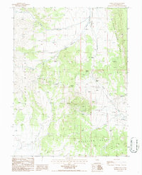
1986 Map of Garden Pass
USGS Topo · Published 1986About this map
Mt Hope dominates the central landscape of this Nevada survey, serving as a focal point for mining and geological exploration in the mid-1980s. The presence of the Mt Hope Mine and the nearby September Morn Mine highlights the era's industrial activity, supported by numerous Prospects scattered across the ridges. The complex drainage of the Great Basin is evident through the courses of Vinini Creek and Henderson Creek, while Tallings Ponds near the base of the mountains indicate the processing of extracted materials.
Find a feature on this map
22 named features on this map. Tap any name to fly to it.
Don’t see what you’re looking for? This feature index may not catch every label — zoom into the map to look around manually.
Map Details
Editions of this 1986 Garden Pass Map
This is the sole edition of this map. No revisions or reprints were ever made.
Other maps of this area

1926 · Roberts Mountains
USGS Topo · 1:250,000

1929 · Roberts Mountains
USGS Topo · 1:250,000

1949 · Garden Valley
USGS Topo · 1:62,500

1949 · Roberts Creek Mtn
USGS Topo · 1:62,500

1951 · Roberts Creek Mtn
USGS Topo · 1:62,500

1951 · Garden Valley
USGS Topo · 1:62,500

1955 · Millett
USGS Topo · 1:250,000

1956 · Bartine Ranch
USGS Topo · 1:62,500

1956 · Whistler Mtn
USGS Topo · 1:62,500

1959 · Millett
USGS Topo · 1:250,000