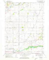
1970 Map of Garden Prairie
USGS Topo · Published 1972About this map
Garden Prairie sits at the southern edge of this northern Illinois landscape, positioned where the Chicago and North Western rail line parallels the meandering course of the Kishwaukee River. The map reveals a rural transition zone along the border of Boone and McHenry counties, characterized by a dense network of country roads like Angling Road and Russellville Road that connect isolated farmsteads and tiny settlements such as Geryune and Lawrenceville. Small rural schools, including Kishwaukee Sch and Hawthorne Sch, remain as landmarks of the local community structure, while several cemeteries like Stone School Cem and East Bonus Cem provide clear points of reference for genealogical research. The presence of numerous Gravel Pits and Quarries near the river suggests an active local extraction industry, contrasting with the agricultural drainage patterns of Piscasaw Creek and Rush Creek to the north.
Find a feature on this map
57 named features on this map. Tap any name to fly to it.
Don’t see what you’re looking for? This feature index may not catch every label — zoom into the map to look around manually.
Map Details
Editions of this 1970 Garden Prairie Map
This is the sole edition of this map. No revisions or reprints were ever made.
Other maps of this area

1918 · Belvidere
USGS Topo · 1:62,500

1918 · Kirkland
USGS Topo · 1:62,500

1932 · Harvard
USGS Topo · 1:48,000

1937 · Harvard
USGS Topo · 1:62,500

1938 · Genoa
USGS Topo · 1:62,500

1944 · Belvidere
USGS Topo · 1:62,500

1954 · Rockford
USGS Topo · 1:250,000

1955 · Rockford
USGS Topo · 1:250,000

1958 · Rockford
USGS Topo · 1:250,000

1963 · Rockford
USGS Topo · 1:250,000