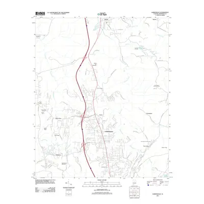
2011 Map of Gardendale
USGS Topo · Published 2011About this map
Gardendale serves as a central hub in this survey, showcasing the suburban expansion of Jefferson County north of Birmingham. The landscape is defined by the winding paths of Black Creek and Cunningham Creek, which weave between ridges like Yellow Bird Mountain and Easterwood Mountain. This map documents a transitional period where established communities like Morris and Mount Olive interface with modern infrastructure, including the dense network of roads such as Old Highway 31 and Carson Rd N. Genealogists and local historians will find significant value in the distribution of family and community burial grounds, including Moncrief Cemetery, Edward Cemetery, and Crooked Creek Cemetery. The eastern portion of the quadrangle highlights the industrial and civic heritage of New Castle, featuring the New Castle Community House and nearby water resources like the Flat Creek Lake Dam.
Find a feature on this map
108 named features on this map. Tap any name to fly to it.
Don’t see what you’re looking for? This feature index may not catch every label — zoom into the map to look around manually.
Map Details
Editions of this 2011 Gardendale Map
This is the sole edition of this map. No revisions or reprints were ever made.
Other maps of this area

1889 · Birmingham
USGS Topo · 1:125,000

1892 · Birmingham
USGS Topo · 1:125,000

1895 · Birmingham
USGS Topo · 1:125,000

1904 · Birmingham Coal District
USGS Topo · 1:62,500

1905 · Leeds
USGS Topo · 1:62,500

1906 · Birmingham Special
USGS Topo · 1:62,500

1907 · Birmingham
USGS Topo · 1:125,000

1907 · Leeds
USGS Topo · 1:62,500

1951 · Warrior
USGS Topo · 1:24,000
1951 · Creel
USGS Topo · 1:24,000