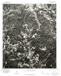
1975 Map of Gardendale
USGS Topo · Published 1977About this map
Gardendale and the surrounding Jefferson County hills are captured here through detailed orthophotography rectified by optical scanning. This 1970s view reveals a landscape defined by the intersection of residential expansion and the dissected Appalachian Plateau terrain. The transition from established clusters like Morris in the north to the growing community of Mt Olive highlights the mid-century development patterns north of Birmingham. Because this is an orthophotoquad, the imagery provides an unfiltered record of land use, showing the literal footprint of clearings, winding residential roads, and the prominent corridor of the highway as it bisected the ridge-and-valley landscape during a period of significant suburban growth.
Find a feature on this map
3 named features on this map. Tap any name to fly to it.
Don’t see what you’re looking for? This feature index may not catch every label — zoom into the map to look around manually.
Map Details
Editions of this 1975 Gardendale Map
This is the sole edition of this map. No revisions or reprints were ever made.
Other maps of this area

1889 · Birmingham
USGS Topo · 1:125,000

1892 · Birmingham
USGS Topo · 1:125,000

1895 · Birmingham
USGS Topo · 1:125,000

1904 · Birmingham Coal District
USGS Topo · 1:62,500

1905 · Leeds
USGS Topo · 1:62,500

1906 · Birmingham Special
USGS Topo · 1:62,500

1907 · Birmingham
USGS Topo · 1:125,000

1907 · Leeds
USGS Topo · 1:62,500

1951 · Warrior
USGS Topo · 1:24,000
1951 · Creel
USGS Topo · 1:24,000