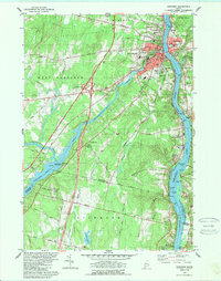
1980 Map of Gardiner
USGS Topo · Published 1989About this map
Gardiner and Randolph face one another across the Kennebec River, a corridor defined by heavy industrial infrastructure and historic transport routes. The Maine Central railroad tracks follow the river's eastern bank through Pittston, while the massive Maine Turnpike and its Interchange 14 cut through the western interior near Cobbosseecontee Stream. This 1980s landscape shows a transition between the dense urban cores of the river towns and the more distributed rural life of West Gardiner and Litchfield.
Find a feature on this map
94 named features on this map. Tap any name to fly to it.
Don’t see what you’re looking for? This feature index may not catch every label — zoom into the map to look around manually.
Map Details
Editions of this 1980 Gardiner Map
3 editions found
Other maps of this area

1892 · Gardiner
USGS Topo · 1:62,500

1892 · Augusta
USGS Topo · 1:62,500

1893 · Vassalboro
USGS Topo · 1:62,500

1893 · Wiscasset
USGS Topo · 1:62,500

1898 · Vassalboro
USGS Topo · 1:62,500

1941 · Vassalboro
USGS Topo · 1:62,500

1941 · Augusta
USGS Topo · 1:62,500

1943 · Augusta
USGS Topo · 1:62,500

1943 · Gardiner
USGS Topo · 1:62,500

1943 · Vassalboro
USGS Topo · 1:62,500