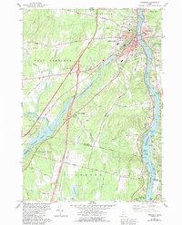
1980 Map of Gardiner
USGS Topo · Published 1991About this map
Gardiner and its neighboring river towns along the Kennebec River define this 1980s landscape, illustrating the enduring relationship between Maine’s interior waterways and its settlement patterns. The river serves as a central artery, separating Randolph and Pittston on the east bank from the urban core of Gardiner and South Gardiner on the west. This period shows the modern infrastructure of the Maine Turnpike cutting through the rural stretches of West Gardiner and Richmond, contrasting with the older grid of the city and the numerous community landmarks. For family historians, the map is remarkably detailed, locating many burial grounds including Oak Grove Cem, St Josephs Cem, and Maple Grove Cem. Significant natural and recreational features are also present, from the waters of Pleasant Pond and Peacock Beach State Park to the prominent heights of Iron Mine Hill and Libby Hill.
Find a feature on this map
75 named features on this map. Tap any name to fly to it.
Don’t see what you’re looking for? This feature index may not catch every label — zoom into the map to look around manually.
Map Details
Editions of this 1980 Gardiner Map
3 editions found
Other maps of this area

1892 · Gardiner
USGS Topo · 1:62,500

1892 · Augusta
USGS Topo · 1:62,500

1893 · Vassalboro
USGS Topo · 1:62,500

1893 · Wiscasset
USGS Topo · 1:62,500

1898 · Vassalboro
USGS Topo · 1:62,500

1941 · Vassalboro
USGS Topo · 1:62,500

1941 · Augusta
USGS Topo · 1:62,500

1943 · Augusta
USGS Topo · 1:62,500

1943 · Gardiner
USGS Topo · 1:62,500

1943 · Vassalboro
USGS Topo · 1:62,500