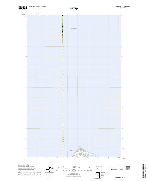
2023 Map of Gardiner OE N
USGS Topo · Published 2023About this map
Protection Island dominates the southern reaches of this maritime survey, serving as a critical sanctuary within the Protection Island National Wildlife Refuge. Situated in the Salish Sea, the island’s distinctive landforms include the elongated spit of Violet Point and the submerged hazard of Dallas Bank to the west. This 2023 edition delineates the aquatic boundary between Clallum and Jefferson counties, which cuts through the open water north of the island. The map illustrates a landscape dedicated almost entirely to conservation, where the lack of terrestrial roads or human settlements reflects the island's role as a protected nesting ground. The sparse label set emphasizes the island’s isolation and its geographic prominence as a landmark for navigation between the Olympic Peninsula and the San Juan Islands.
Find a feature on this map
8 named features on this map. Tap any name to fly to it.
Don’t see what you’re looking for? This feature index may not catch every label — zoom into the map to look around manually.
Map Details
Editions of this 2023 Gardiner OE N Map
This is the sole edition of this map. No revisions or reprints were ever made.
Other maps of this area

1938 · Dungeness
USGS Topo · 1:62,500

1939 · Port Townsend
USGS Topo · 1:62,500

1939 · Dungeness
USGS Topo · 1:62,500

1943 · Richardson
USGS Topo · 1:62,500

1953 · Port Townsend North
USGS Topo · 1:24,000
1953 · Port Townsend South
USGS Topo · 1:24,000
1953 · Gardiner
USGS Topo · 1:24,000

1956 · Sequim
USGS Topo · 1:24,000

1957 · Richardson
USGS Topo · 1:62,500

1957 · Victoria
USGS Topo · 1:250,000