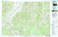
1992 Map of Gardiner
USGS Topo · Published 1993About this map
Paradise Valley serves as a dramatic corridor for the Yellowstone River and the Burlington Northern RR as they move toward the North Entrance of Yellowstone National Park. This early 1990s survey illustrates the complex geography where the Gallatin Range meets the Absaroka Range, creating the narrows of Yankee Jim Canyon. The settlement pattern follows the river and the path of U.S. Highway 89, connecting the gateway community of Gardiner with agricultural and recreational spots like Chico Hot Springs and Emigrant. High-elevation landmarks such as Electric Peak and Mount Douglas dominate the horizon, while the Absaroka-Beartooth Wilderness encompasses the wild drainages of Slough Creek and the Stillwater River to the east.
Find a feature on this map
44 named features on this map. Tap any name to fly to it.
Don’t see what you’re looking for? This feature index may not catch every label — zoom into the map to look around manually.
Map Details
Editions of this 1992 Gardiner Map
2 editions found
Other maps of this area

1885 · Gallatin
USGS Topo · 1:125,000

1885 · Gallatin
USGS Topo · 1:125,000

1886 · Canyon
USGS Topo · 1:125,000

1888 · Three Forks
USGS Topo · 1:250,000

1891 · Livingston
USGS Topo · 1:250,000

1891 · Big Timber
USGS Topo · 1:125,000

1893 · Livingston
USGS Topo · 1:250,000

1893 · Big Timber
USGS Topo · 1:125,000

1894 · Three Forks
USGS Topo · 1:250,000

1895 · Three Forks
USGS Topo · 1:250,000