
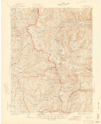
1945 Map of Garfield
USGS Topo · Published 1945About this map
High-altitude mining camps and the hard-won infrastructure of the Central Rockies define this 1945 survey. The Continental Divide snakes through the center of the sheet, separating the drainages of Chalk Creek in the east from Tomichi Creek in the southwest. Settlements like St Elmo and Romley are clustered along the narrow gulches, supported by a network of steep transportation routes including the Cumberland Pass Road and the Old Alpine Tunnel.
Find a feature on this map
109 named features on this map. Tap any name to fly to it.
Don’t see what you’re looking for? This feature index may not catch every label — zoom into the map to look around manually.
Map Details
Editions of this 1945 Garfield Map
2 editions found
Other maps of this area

1934 · Taylor Park
USGS Topo · 1:62,500

1937 · Taylor Park
USGS Topo · 1:62,500

1940 · Garfield
USGS Topo · 1:62,500

1941 · Pitkin
USGS Topo · 1:62,500

1945 · Pitkin
USGS Topo · 1:62,500

1955 · Buena Vista
USGS Topo · 1:62,500

1955 · Mount Harvard
USGS Topo · 1:62,500

1956 · Poncha Springs
USGS Topo · 1:62,500

1956 · Montrose
USGS Topo · 1:250,000

1959 · Montrose
USGS Topo · 1:250,000