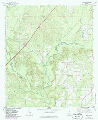
1971 Map of Garland
USGS Topo · Published 1986About this map
Garland sits at the heart of this southern Alabama landscape, where the Seaboard railroad cuts a straight line through the drainage basins of the Sepulga River and Persimmon Creek. The map documents a rural community defined by a dense network of country churches and family burial grounds, including Belmont No 1 Ch, St John Ch, and the McClure Cem. The topography reveals the winding paths of Long Creek and Panther Creek as they navigate the ridges of the Butler and Conecuh county line.
Find a feature on this map
21 named features on this map. Tap any name to fly to it.
Don’t see what you’re looking for? This feature index may not catch every label — zoom into the map to look around manually.
Map Details
Editions of this 1971 Garland Map
2 editions found
Other maps of this area

1953 · Andalusia
USGS Topo · 1:250,000

1957 · Andalusia
USGS Topo · 1:250,000

1971 · Lyeffion
USGS Topo · 1:24,000

1971 · Brooks
USGS Topo · 1:24,000

1971 · Mc Kenzie
USGS Topo · 1:24,000

1971 · Georgiana East
USGS Topo · 1:24,000

1971 · Garland
USGS Topo · 1:24,000

1971 · Bethel
USGS Topo · 1:24,000

1971 · Georgiana West
USGS Topo · 1:24,000

1982 · Evergreen
USGS Topo · 1:24,000