1985 Map of Garnett
USGS Topo · Published 1985About this map
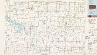
Garnett and the surrounding Anderson County countryside were undergoing significant hydrological and transport shifts by the mid-1980s. The landscape is defined by massive water management projects, most notably the Wolf Creek Reservoir and the John Redmond Reservoir, which altered the historical flow of the Neosho River. Near the confluence of these waters, the Flint Hills National Wildlife Refuge provides a protected haven within the eastern Kansas plains.
Find a feature on this map
117 named features on this map. Tap any name to fly to it.
Don’t see what you’re looking for? This feature index may not catch every label — zoom into the map to look around manually.
Map Details
Editions of this 1985 Garnett Map
This is the sole edition of this map. No revisions or reprints were ever made.
Other maps of this area

1884 · Fort Scott
USGS Topo · 1:125,000

1885 · Eskridge
USGS Topo · 1:125,000

1885 · Burlington
USGS Topo · 1:125,000

1885 · Eureka
USGS Topo · 1:125,000

1885 · Garnett
USGS Topo · 1:125,000

1885 · Lawrence
USGS Topo · 1:125,000

1886 · Fredonia
USGS Topo · 1:125,000

1886 · Iola
USGS Topo · 1:125,000

1886 · Fort Scott
USGS Topo · 1:125,000

1887 · Olathe
USGS Topo · 1:125,000