1990 Map of Garnett
USGS Topo · Published 1990About this map
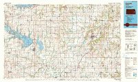
The Neosho River and Marais des Cygnes River systems define the geography of this east-central Kansas landscape, where the prairie meets the expanding water resources of the late 20th century. By 1990, the region had been transformed by significant engineering projects including the John Redmond Reservoir, Melvern Lake, and the cooling waters of Wolf Creek Reservoir. These reservoirs sit alongside long-established rail corridors, including the Atchison Topeka and Santa Fe Railway and the Missouri Pacific Railroad, which historically linked agricultural hubs like Garnett, Burlington, and Westphalia. The map preserves the locations of smaller rural communities such as the historic French-settlement site of Silkville and the town of Williamsburg. Large conservation areas like the Otter Creek State Wildlife Area flank the major water bodies, while the high point at Blue Mound stands out in the southeastern corner, overlooking the network of creeks that feed the Little Osage River.
Find a feature on this map
107 named features on this map. Tap any name to fly to it.
Don’t see what you’re looking for? This feature index may not catch every label — zoom into the map to look around manually.
Map Details
Editions of this 1990 Garnett Map
This is the sole edition of this map. No revisions or reprints were ever made.
Other maps of this area

1884 · Fort Scott
USGS Topo · 1:125,000

1885 · Eskridge
USGS Topo · 1:125,000

1885 · Burlington
USGS Topo · 1:125,000

1885 · Eureka
USGS Topo · 1:125,000

1885 · Garnett
USGS Topo · 1:125,000

1885 · Lawrence
USGS Topo · 1:125,000

1886 · Fredonia
USGS Topo · 1:125,000

1886 · Iola
USGS Topo · 1:125,000

1886 · Fort Scott
USGS Topo · 1:125,000

1887 · Olathe
USGS Topo · 1:125,000