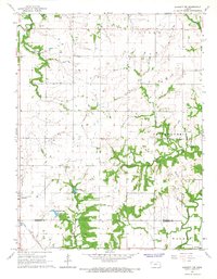
1966 Map of Garnett NW
USGS Topo · Published 1967About this map
Pottawatomie Creek and its many winding tributaries define the rural landscape of eastern Kansas in the mid-1960s. The northern reaches of Richmond sit adjacent to the Atchison Topeka and Santa Fe railroad, which cuts a straight diagonal across the southwestern township lines. The area is characterized by the transition from agriculture to natural drainage basins, with South Fork Pottawatomie Creek and Middle Branch carving through the terrain. Evidence of the region's natural resource extraction is visible through scattered Oil Wells in the northeast and a Quarry near the eastern boundary. This survey captures local landmarks of genealogical importance, such as Baker Cem and Berea Cem, alongside recreational and utility features like Richmond Lake and a Radio Tower. The map provides a detailed view of the civil divisions between Ohio, Cutler, and Richmond townships as they existed before modern suburban expansion.
Find a feature on this map
25 named features on this map. Tap any name to fly to it.
Don’t see what you’re looking for? This feature index may not catch every label — zoom into the map to look around manually.
Map Details
Editions of this 1966 Garnett NW Map
2 editions found
Other maps of this area

1885 · Garnett
USGS Topo · 1:125,000

1885 · Lawrence
USGS Topo · 1:125,000

1889 · Lawrence
USGS Topo · 1:125,000

1894 · Garnett
USGS Topo · 1:125,000

1947 · Lawrence
USGS Topo · 1:250,000

1950 · Lawrence
USGS Topo · 1:250,000

1956 · Ottawa South
USGS Topo · 1:24,000

1956 · Lawrence
USGS Topo · 1:250,000

1961 · Lawrence
USGS Topo · 1:250,000
1962 · Peoria
USGS Topo · 1:24,000