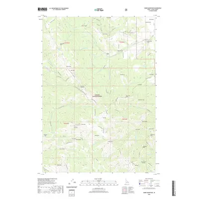
2020 Map of Garns Mountain
USGS Topo · Published 2020About this map
Targhee National Forest encompasses the high-elevation terrain of the Big Hole Mountains, where numerous peaks and ridges define the eastern Idaho landscape. This area is characterized by steep drainages like Pintar Canyon and notable geological formations including Red Butte and Castle Rock. Evidence of early 20th-century industry remains at the Idaho Mine near Idaho Ridge, while the network of forest roads and trails, such as the Grandview-Relay and Kirkham-Relay, speaks to the long-standing management of these timberlands.
Find a feature on this map
90 named features on this map. Tap any name to fly to it.
Don’t see what you’re looking for? This feature index may not catch every label — zoom into the map to look around manually.
Map Details
Editions of this 2020 Garns Mountain Map
This is the sole edition of this map. No revisions or reprints were ever made.
Other maps of this area

1943 · Driggs
USGS Topo · 1:62,500

1943 · Garns Mtn
USGS Topo · 1:62,500

1946 · Driggs
USGS Topo · 1:62,500

1946 · Garns Mtn
USGS Topo · 1:62,500

1955 · Driggs
USGS Topo · 1:250,000

1958 · Driggs
USGS Topo · 1:250,000

1962 · Driggs
USGS Topo · 1:250,000

1965 · Packsaddle Lake
USGS Topo · 1:24,000
1965 · Wright Creek
USGS Topo · 1:24,000
1965 · Tetonia
USGS Topo · 1:24,000