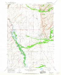
1965 Map of Tetonia
USGS Topo · Published 1967About this map
Teton River meanders through the western Teton Basin, creating a distinctive network of wetlands and spring-fed channels in this mid-1960s survey. The landscape is defined by its water management and transport infrastructure, featuring the Union Pacific rail line and an abandoned Old Grade that parallel the valley floor. Small agricultural settlements like Tetonia, Felt, and Badger serve as focal points for the surrounding rural community. Cultural history is preserved in several burial grounds, including the Felt Cem, Haden Cem, and Cache-Clawson Cem. The transition from the river basin to higher elevations is marked by prominent natural features such as Packsaddle and the drainage of South Leigh Creek. Numerous gravel pits and the Hog Canal reflect the local economy's reliance on the land's resources and irrigation.
Find a feature on this map
25 named features on this map. Tap any name to fly to it.
Don’t see what you’re looking for? This feature index may not catch every label — zoom into the map to look around manually.
Map Details
Editions of this 1965 Tetonia Map
3 editions found
Other maps of this area

1943 · Driggs
USGS Topo · 1:62,500

1943 · Garns Mtn
USGS Topo · 1:62,500

1946 · Driggs
USGS Topo · 1:62,500

1946 · Garns Mtn
USGS Topo · 1:62,500

1955 · Driggs
USGS Topo · 1:250,000

1958 · Driggs
USGS Topo · 1:250,000

1962 · Driggs
USGS Topo · 1:250,000

1965 · Lamont
USGS Topo · 1:24,000

1965 · Packsaddle Lake
USGS Topo · 1:24,000

1965 · Mc Renolds Reservoir
USGS Topo · 1:24,000