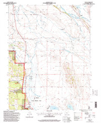
1994 Map of Garo
USGS Topo · Published 1998About this map
Middle Fork South Platte River and its myriad irrigation channels define this high-altitude cattle ranching landscape in Park County. By the 1990s, the area retained a network of family-named holdings, including McDowell Ranch, Cargill Ranch, and Rogers Ranch, alongside the former Weston site. Water management is the primary human imprint on the land, evidenced by an intricate system of ditches such as the Miller Ditch, Nelson Ditch, and Guiraud Ditch, which redirect snowmelt across the valley floor toward the Antero Reservoir.
Find a feature on this map
43 named features on this map. Tap any name to fly to it.
Don’t see what you’re looking for? This feature index may not catch every label — zoom into the map to look around manually.
Map Details
Editions of this 1994 Garo Map
This is the sole edition of this map. No revisions or reprints were ever made.
Other maps of this area

1889 · Leadville
USGS Topo · 1:125,000

1891 · Leadville
USGS Topo · 1:125,000

1942 · Leadville
USGS Topo · 1:125,000

1953 · Denver
USGS Topo · 1:250,000

1954 · Pueblo
USGS Topo · 1:250,000

1955 · Buena Vista
USGS Topo · 1:62,500

1956 · Elkhorn
USGS Topo · 1:24,000

1956 · Garo
USGS Topo · 1:24,000

1956 · Antero Reservoir
USGS Topo · 1:24,000

1956 · Antero Reservoir NE
USGS Topo · 1:24,000