
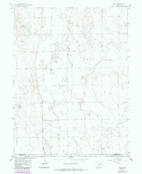
1965 Map of Gary
USGS Topo · Published 1967About this map
Gary sits at the intersection of local water and energy infrastructure in the mid-1960s, a period of transition for this part of the high plains. The landscape is defined by the winding paths of Beaver Creek and Buck Creek, which cut through the terrain alongside an extensive network of Wells and modern utility corridors. A prominent Pipeline and Aqueduct cross the landscape, signaling the area's importance to regional water management and the burgeoning petroleum industry, evidenced by numerous Oil Wells and Drill Holes. To the south, the Base Line serves as a primary survey boundary, separating the topography into distinct sections. Near the western edge, the small settlement of Stivers appears as a quiet counterpart to the more active infrastructure appearing across the Morgan County and Washington County line.
Find a feature on this map
11 named features on this map. Tap any name to fly to it.
Don’t see what you’re looking for? This feature index may not catch every label — zoom into the map to look around manually.
Map Details
Editions of this 1965 Gary Map
2 editions found
Other maps of this area

1954 · Limon
USGS Topo · 1:250,000

1954 · Sterling
USGS Topo · 1:250,000

1957 · Limon
USGS Topo · 1:250,000

1958 · Limon
USGS Topo · 1:250,000

1958 · Sterling
USGS Topo · 1:250,000

1963 · Round Top
USGS Topo · 1:24,000

1965 · Huey Ranch
USGS Topo · 1:24,000

1965 · Miller Ranch
USGS Topo · 1:24,000

1973 · Woodrow
USGS Topo · 1:24,000

1973 · Antelope Creek West
USGS Topo · 1:24,000