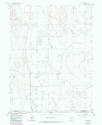
1965 Map of Gary
USGS Topo · Published 1984About this map
Gary and the small settlement of Stivers anchor this mid-century survey of the high plains along the border of Morgan and Washington counties. The landscape is defined by the winding course of Beaver Creek and the drainage of Buck Creek, set against a rural grid marked by extensive industrial and agricultural infrastructure. Numerous wells and oil wells dot the terrain, signaling the importance of energy extraction in this region. Significant utility corridors, including a Pipeline and an Aqueduct, cut across the sections, while Gary Road provides the primary north-south transit. Modern updates to the 1965 survey are captured in purple revisions from the early 1980s, documenting fine-grained changes like fence lines and local developments that shaped this portion of the eastern Colorado plains.
Find a feature on this map
13 named features on this map. Tap any name to fly to it.
Don’t see what you’re looking for? This feature index may not catch every label — zoom into the map to look around manually.
Map Details
Editions of this 1965 Gary Map
2 editions found
Other maps of this area

1954 · Limon
USGS Topo · 1:250,000

1954 · Sterling
USGS Topo · 1:250,000

1957 · Limon
USGS Topo · 1:250,000

1958 · Limon
USGS Topo · 1:250,000

1958 · Sterling
USGS Topo · 1:250,000

1963 · Round Top
USGS Topo · 1:24,000

1965 · Gary
USGS Topo · 1:24,000

1965 · Huey Ranch
USGS Topo · 1:24,000

1965 · Miller Ranch
USGS Topo · 1:24,000

1973 · Woodrow
USGS Topo · 1:24,000