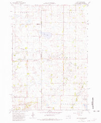
1967 Map of Gary NW
USGS Topo · Published 1981About this map
Antelope Valley defines the landscape of this borderlands region in the late 1960s, where the prairie of South Dakota meets the marshlands of western Minnesota. The map documents a rural environment organized by townships like Adams, Augusta, and Mehurin, characterized by small-scale civic and spiritual centers such as the Antelope Valley Ch and its neighboring Antelope Valley Cem. To the north, Salt Lake sits as a prominent hydrologic feature near the county line, while the southern portion of the sheet is dominated by the complex drainage of the Lac qui Parle River and the West Branch Lac qui Parle River. Local governance is evidenced by the isolated Townhall near the eastern border. The conservation efforts of the era are visible at the Dacotah State Wildlife Management Area, preserving the natural character of the terrain amidst scattered agricultural improvements and local landmarks like Bolland Slough.
Find a feature on this map
24 named features on this map. Tap any name to fly to it.
Don’t see what you’re looking for? This feature index may not catch every label — zoom into the map to look around manually.
Map Details
Editions of this 1967 Gary NW Map
4 editions found
Other maps of this area

1953 · Bellingham
USGS Topo · 1:62,500

1953 · Milbank
USGS Topo · 1:250,000

1953 · Watertown
USGS Topo · 1:250,000

1958 · Milbank
USGS Topo · 1:250,000

1958 · Watertown
USGS Topo · 1:250,000

1967 · Gary
USGS Topo · 1:24,000

1967 · Gary SE
USGS Topo · 1:24,000

1967 · Gary NW
USGS Topo · 1:24,000
1967 · Mount Wickham
USGS Topo · 1:24,000

1971 · Marietta
USGS Topo · 1:24,000
Featured Places
- Glenwood Township, SD
- Antelope Valley Township, SD
- Lac qui Parle County, MN
- Deuel County, SD
- Grant County, SD