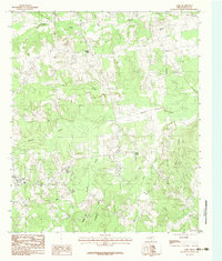
1983 Map of Gary
USGS Topo · Published 1983About this map
The town of Gary anchor this Panola County landscape in the early 1980s, serving as a focal point for a network of rural settlements including Shady Grove and Antioch. The terrain is defined by a dense system of waterways, where the meandering path of Murvaul Creek is joined by numerous tributaries like Beech Creek and Nail Creek. The topographic detail reveals a series of prominent elevations that break the local relief, specifically Sixmile Hill, Risinger Hill, and Henderson Hill. Historically established communities such as Pleasant Ridge and Woods are shown connected by a winding road network that follows the natural contours of the land. This survey illustrates the persistent rural character of eastern Texas, where small crossroads like Elm and Sixmile remained active nodes of community life decades after their initial settlement, all while the landscape was shaped by the hydrology of Holmes Bayou and Hooker Branch.
Find a feature on this map
21 named features on this map. Tap any name to fly to it.
Don’t see what you’re looking for? This feature index may not catch every label — zoom into the map to look around manually.
Map Details
Editions of this 1983 Gary Map
This is the sole edition of this map. No revisions or reprints were ever made.
Other maps of this area

1945 · Socagee Bayou
USGS Topo · 1:62,500

1953 · Palestine
USGS Topo · 1:250,000

1956 · Tyler
USGS Topo · 1:250,000

1956 · Deadwood
USGS Topo · 1:62,500

1957 · Palestine
USGS Topo · 1:250,000

1958 · Center
USGS Topo · 1:62,500

1958 · Timpson
USGS Topo · 1:62,500

1958 · Carthage
USGS Topo · 1:62,500
1983 · River Hill
USGS Topo · 1:24,000
1983 · Old Center
USGS Topo · 1:24,000