
1994 Map of Garza Peak
USGS Topo · Published 1994About this map
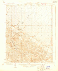
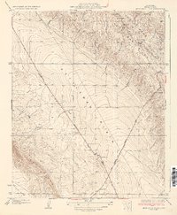
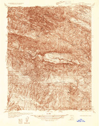
Kettleman Plain and the surrounding high ridges define this landscape on the border of Kings and Fresno Counties. By the early 1990s, the development of the Avenal State Prison at the base of the Kreyenhagen Hills had fundamentally shifted the character of the area near Avenal. The topography is a study in sharp contrasts, where the flat alluvial expanses of Sunflower Valley give way to the complex folding of Reef Ridge and the Chalk Buttes. Scattered through these uplands are numerous water sources essential for this environment, such as King Wade Baxter Spring and Dirty Spring. Resource extraction and prospecting remain evident across the hills, marked by the Dawson Mine and various drill holes, while the heights of Garza Peak and Zwang Peak provide a vista over the ancient marine sediments that characterize the geological history of the Central Valley edge.
Find a feature on this map
33 named features on this map. Tap any name to fly to it.
Don’t see what you’re looking for? This feature index may not catch every label — zoom into the map to look around manually.
Map Details
Editions of this 1994 Garza Peak Map
This is the sole edition of this map. No revisions or reprints were ever made.
Other maps of this area

1912 · Coalinga
USGS Topo · 1:125,000

1914 · Cholame
USGS Topo · 1:125,000

1915 · Cholame
USGS Topo · 1:125,000

1917 · Cholame
USGS Topo · 1:125,000
1930 · Discovery Well
USGS Topo · 1:31,680

1930 · Canoas Creek
USGS Topo · 1:31,680

1930 · Kettleman Plain
USGS Topo · 1:31,680
1933 · Kettleman Plain
USGS Topo · 1:31,680
1934 · The Dark Hole
USGS Topo · 1:31,680

1934 · Reef Ridge
USGS Topo · 1:31,680