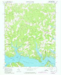
1963 Map of Gasburg
USGS Topo · Published 1980About this map
Lake Gaston dominates the southern landscape, where the flooding of the Roanoke River valley reshaped the border between Virginia and North Carolina. This survey, photorevised in 1980, captures the rural character of Brunswick and Northampton counties during the early years of the reservoir. Numerous small family burial grounds, such as Powell Cem and Wright Cem, remain scattered across the uplands, providing valuable data for genealogists. The settlement at Gasburg serves as a local hub near the winding inlets of Lizard Creek, while smaller communities like Ebony and Ankura are linked by a network of unimproved and light-duty roads. Local spiritual life is well-documented through a concentration of rural meeting houses, including St Pauls Chapel and Roanoke Chapel, many of which overlook the newly created shoreline of the lake and its various branches, such as Pea Hill Creek.
Find a feature on this map
37 named features on this map. Tap any name to fly to it.
Don’t see what you’re looking for? This feature index may not catch every label — zoom into the map to look around manually.
Map Details
Editions of this 1963 Gasburg Map
4 editions found
Other maps of this area

1919 · White Plains
USGS Topo · 1:48,000

1920 · White Plains
USGS Topo · 1:62,500

1953 · Norfolk
USGS Topo · 1:250,000

1953 · Greensboro
USGS Topo · 1:250,000

1954 · Greensboro
USGS Topo · 1:250,000

1962 · Greensboro
USGS Topo · 1:250,000

1963 · Powellton
USGS Topo · 1:24,000

1963 · Gasburg
USGS Topo · 1:24,000

1963 · Valentines
USGS Topo · 1:24,000

1963 · White Plains
USGS Topo · 1:24,000