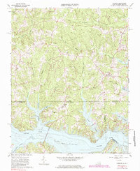
1963 Map of Gasburg
USGS Topo · Published 1985About this map
Lake Gaston dominates the southern landscape of this Virginia-North Carolina border country, where the Roanoke River was transformed into a massive reservoir. Small agricultural settlements like Gasburg and Ebony serve as local hubs, surrounded by a dense network of family cemeteries and rural parishes. Genealogists will find significant value in the documentation of family-named plots such as Reid Cem, Kirkland Cem, Powell Cem, and Wright Cem. The topography is defined by the drainages of Lizard Creek and Songbird Creek, which flow toward the inundated valley. The inclusion of Songbird Mill Creek suggests the area's earlier water-powered industry, while numerous small chapels, including Roanoke Chapel and St Pauls Chapel, indicate the scattered but tight-knit nature of these borderland communities during the early 1960s.
Find a feature on this map
40 named features on this map. Tap any name to fly to it.
Don’t see what you’re looking for? This feature index may not catch every label — zoom into the map to look around manually.
Map Details
Editions of this 1963 Gasburg Map
4 editions found
Other maps of this area

1919 · White Plains
USGS Topo · 1:48,000

1920 · White Plains
USGS Topo · 1:62,500

1953 · Norfolk
USGS Topo · 1:250,000

1953 · Greensboro
USGS Topo · 1:250,000

1954 · Greensboro
USGS Topo · 1:250,000

1962 · Greensboro
USGS Topo · 1:250,000

1963 · Powellton
USGS Topo · 1:24,000

1963 · Gasburg
USGS Topo · 1:24,000

1963 · Valentines
USGS Topo · 1:24,000

1963 · White Plains
USGS Topo · 1:24,000