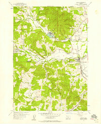
1956 Map of Gaston
USGS Topo · Published 1958About this map
Stimson Mill serves as a central industrial landmark in this mid-1950s survey of the northern Willamette Valley foothills. The landscape is defined by the transition from the timbered slopes of Mt Richmond down to the productive Patton Valley and the drained Wapato Lake Bed. Timber interests are prominent, evidenced by the Logging Railroad winding through Scoggin Valley toward the millpond.
Find a feature on this map
40 named features on this map. Tap any name to fly to it.
Don’t see what you’re looking for? This feature index may not catch every label — zoom into the map to look around manually.
Map Details
Editions of this 1956 Gaston Map
3 editions found
Other maps of this area

1941 · Timber
USGS Topo · 1:62,500

1941 · Gales Creek
USGS Topo · 1:62,500

1941 · Yamhill
USGS Topo · 1:62,500

1942 · Yamhill
USGS Topo · 1:62,500

1942 · Fairdale
USGS Topo · 1:62,500

1948 · Vancouver
USGS Topo · 1:250,000

1950 · Vancouver
USGS Topo · 1:250,000

1950 · Vancouver
USGS Topo · 1:250,000

1955 · Timber
USGS Topo · 1:62,500

1955 · Fairdale
USGS Topo · 1:62,500