1914 Map of Gastonia
USGS Topo · Published 1954About this map
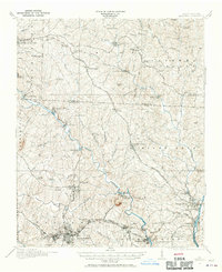
Gastonia and the surrounding textile and milling districts of North Carolina are caught here during a period of significant industrial expansion. The Southern and Seaboard Air Line railroads anchor the regional economy, connecting the larger hubs to smaller industrial outposts like High Shoals, Hardins Sta., and Lowell. Evidence of the area's earlier iron-working history is preserved in the label for Rehoboth Furnace near the Reinhardt Bridge. The landscape is a network of rural life and early manufacturing, punctuated by numerous community anchors such as Belmont Abbey, Philadelphia Church, and several schools like Zion School and Pinegrove School. From the South Fork River to the banks of the Catawba River, this survey provides a fine-grained view of early twentieth-century Gaston and Lincoln counties, including institutional landmarks like the County House and County Home.
Find a feature on this map
90 named features on this map. Tap any name to fly to it.
Don’t see what you’re looking for? This feature index may not catch every label — zoom into the map to look around manually.
Map Details
Editions of this 1914 Gastonia Map
2 editions found
Other maps of this area

1893 · Statesville
USGS Topo · 1:125,000

1895 · Hickory
USGS Topo · 1:125,000

1905 · Charlotte
USGS Topo · 1:48,000

1906 · Kings Mountain
USGS Topo · 1:62,500

1907 · Charlotte
USGS Topo · 1:62,500

1908 · Kings Mountain
USGS Topo · 1:62,500

1909 · Lincolnton
USGS Topo · 1:62,500

1911 · Lincolnton
USGS Topo · 1:62,500

1914 · Gastonia
USGS Topo · 1:48,000

1916 · Gastonia
USGS Topo · 1:62,500