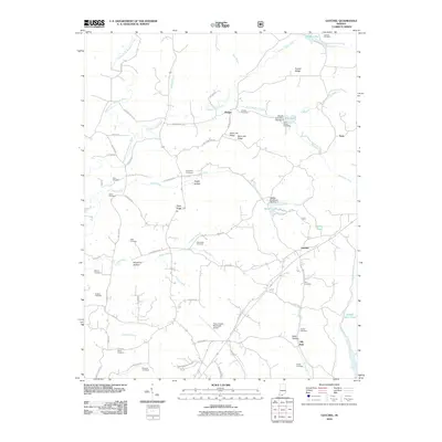
2010 Map of Gatchel
USGS Topo · Published 2010About this map
Gatchel and Ranger serve as the primary hubs in this part of Perry County, where the landscape is defined by the winding Middle Fork Anderson River and the high elevations of Saint Joe Ridge and French Ridge. This 2010 survey reveals a community deeply connected to its past through a dense network of family and community burial grounds, such as Lanman Cemetery, Slaughter Cemetery, and Nixon Cemetery. The modern infrastructure of the Perry County Municipal Airport contrasts with the traditional rural layout of the surrounding hollows, including Hogan Hollow and Harpenau Hollow. Water management is prominent throughout the quadrangle, evidenced by the presence of several reservoirs and dams, including Tipsaw Lake, Saddle Lake, and Gatchel Pond, which provide recreational and ecological value to the region’s rolling geography.
Find a feature on this map
77 named features on this map. Tap any name to fly to it.
Don’t see what you’re looking for? This feature index may not catch every label — zoom into the map to look around manually.
Map Details
Editions of this 2010 Gatchel Map
This is the sole edition of this map. No revisions or reprints were ever made.
Other maps of this area

1900 · St Meinrad
USGS Topo · 1:62,500

1903 · St. Meinrad
USGS Topo · 1:62,500

1903 · Tell City
USGS Topo · 1:62,500

1934 · Cannelton
USGS Topo · 1:62,500

1949 · Cannelton
USGS Topo · 1:24,000

1953 · Cannelton
USGS Topo · 1:24,000

1953 · Tell City
USGS Topo · 1:24,000
1953 · Rome
USGS Topo · 1:24,000

1954 · Evansville
USGS Topo · 1:250,000

1954 · Derby
USGS Topo · 1:24,000