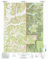
1993 Map of Gatchel
USGS Topo · Published 1996About this map
The Middle Fork Anderson River and its numerous tributaries, including Sulphur Fork Creek and Kraus Creek, carve through the southern Indiana landscape of Perry County. This 1993 revision, based on photography from the 1950s and 1980s, highlights a rural region dominated by the Hoosier National Forest and the Ferdinand State Forest. The map captures a detailed distribution of local institutions, from country churches like St Josephs Ch and Lilly Dale Ch to education sites such as the Theis Sch. High ridges, including St Joe Ridge and French Ridge, define the local topography, while the Perry County Municipal Airport provides a modern navigational anchor. Genealogists will find a concentration of family-named cemeteries, such as Slaughter Cem, Niles Cem, and Mackey Cem, scattered across the drainages of Hogan Hollow and Bolin Hollow.
Find a feature on this map
48 named features on this map. Tap any name to fly to it.
Don’t see what you’re looking for? This feature index may not catch every label — zoom into the map to look around manually.
Map Details
Editions of this 1993 Gatchel Map
This is the sole edition of this map. No revisions or reprints were ever made.
Other maps of this area

1900 · St Meinrad
USGS Topo · 1:62,500

1903 · St. Meinrad
USGS Topo · 1:62,500

1903 · Tell City
USGS Topo · 1:62,500

1934 · Cannelton
USGS Topo · 1:62,500

1949 · Cannelton
USGS Topo · 1:24,000

1953 · Cannelton
USGS Topo · 1:24,000

1953 · Tell City
USGS Topo · 1:24,000
1953 · Rome
USGS Topo · 1:24,000

1954 · Evansville
USGS Topo · 1:250,000

1954 · Derby
USGS Topo · 1:24,000