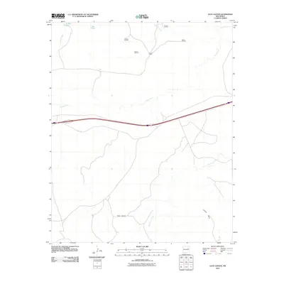
2010 Map of Gate Canyon
USGS Topo · Published 2010About this map
Luciano Mesa dominates the southern landscape of this Guadalupe County region, where the high desert terrain is defined by a network of drainage systems like Gate Canyon and Bull Canyon Creek. In this arid environment, the placement of water resources is critical, evidenced by the strategic locations of De Baca Tank and Pass Tank. The area's ranching infrastructure is clearly marked by several named water-drawing sites, including Knowles Windmill, Orchard Windmill, and Sparks Windmill. These features, along with the settlement at Roman Camp, illustrate the human adaptation to the expansive New Mexico plains. The map also traces the winding paths of Caracita Creek and Pajarito Creek as they navigate the basin north of the interstate corridor.
Find a feature on this map
12 named features on this map. Tap any name to fly to it.
Don’t see what you’re looking for? This feature index may not catch every label — zoom into the map to look around manually.
Map Details
Editions of this 2010 Gate Canyon Map
This is the sole edition of this map. No revisions or reprints were ever made.
Other maps of this area

1954 · Santa Fe
USGS Topo · 1:250,000

1954 · Fort Sumner
USGS Topo · 1:250,000

1958 · Fort Sumner
USGS Topo · 1:250,000

1958 · Santa Fe
USGS Topo · 1:250,000

1964 · Neafus Ranch
USGS Topo · 1:24,000

1964 · Muniz Canyon
USGS Topo · 1:24,000

1964 · Gate Canyon
USGS Topo · 1:24,000

1964 · Newkirk
USGS Topo · 1:24,000
1964 · Salt Lake
USGS Topo · 1:24,000
1964 · Montoya
USGS Topo · 1:24,000