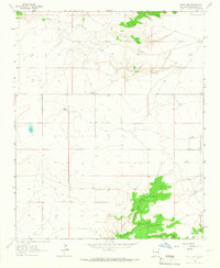
1964 Map of Salt Lake
USGS Topo · Published 1967About this map
Armstrong Ranch and other isolated homesteads anchor this high-plains landscape in Guadalupe County, captured just after the mid-century. The terrain is defined by its scarce water sources, most notably the namesake Salt Lake and the vital Valencia Spring. These features, along with Pajarito Creek in the north and the winding Arroyo Cuervo in the south, dictated the placement of ranching operations like the Bedford Ranch and Scott Ranch. The map illustrates a network of unimproved roads and light-duty trails that connect these remote outposts, reflecting the enduring cattle-ranching economy of eastern New Mexico. Large stretches of open range between the drainage basins emphasize the scale of these private landholdings, where survival depended on the specific location of seasonal springs and perennial creek beds.
Find a feature on this map
7 named features on this map. Tap any name to fly to it.
Don’t see what you’re looking for? This feature index may not catch every label — zoom into the map to look around manually.
Map Details
Editions of this 1964 Salt Lake Map
This is the sole edition of this map. No revisions or reprints were ever made.
Other maps of this area

1954 · Santa Fe
USGS Topo · 1:250,000

1954 · Fort Sumner
USGS Topo · 1:250,000

1958 · Fort Sumner
USGS Topo · 1:250,000

1958 · Santa Fe
USGS Topo · 1:250,000

1963 · Cuervo
USGS Topo · 1:24,000

1964 · Canada Colorado
USGS Topo · 1:24,000

1964 · Fallon Ranch
USGS Topo · 1:24,000

1964 · Gate Canyon
USGS Topo · 1:24,000

1964 · Newkirk
USGS Topo · 1:24,000
1964 · Harben Lake
USGS Topo · 1:24,000