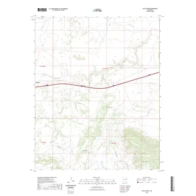
2023 Map of Gate Canyon
USGS Topo · Published 2023About this map
Newkirk serves as a primary reference point in this high plains landscape of eastern New Mexico, where the land is carved by intricate drainage systems. The northern reaches are defined by the winding course of Pajarito Creek and Caracita Creek, while the southern terrain rises toward the prominent Luciano Mesa. This area is marked by significant topographical relief, visible in the deep cuts of Gate Canyon and Captivas Canyon. Essential water sources, such as De Baca Tank and Pass Tank, illustrate the pastoral infrastructure required for ranching in this arid environment. A network of local roads and trails, including Bull Canyon Loop and Old Cabin Ln, provides access across the various townships and ranges that divide this portion of Guadalupe Co.
Find a feature on this map
19 named features on this map. Tap any name to fly to it.
Don’t see what you’re looking for? This feature index may not catch every label — zoom into the map to look around manually.
Map Details
Editions of this 2023 Gate Canyon Map
This is the sole edition of this map. No revisions or reprints were ever made.
Other maps of this area

1954 · Santa Fe
USGS Topo · 1:250,000

1954 · Fort Sumner
USGS Topo · 1:250,000

1958 · Fort Sumner
USGS Topo · 1:250,000

1958 · Santa Fe
USGS Topo · 1:250,000

1964 · Neafus Ranch
USGS Topo · 1:24,000

1964 · Muniz Canyon
USGS Topo · 1:24,000

1964 · Gate Canyon
USGS Topo · 1:24,000

1964 · Newkirk
USGS Topo · 1:24,000
1964 · Salt Lake
USGS Topo · 1:24,000
1964 · Montoya
USGS Topo · 1:24,000