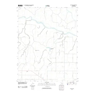
2010 Map of Gate NW
USGS Topo · Published 2010About this map
The Cimarron River winds across this northern Oklahoma landscape, carving a wide path through the prairie terrain in Beaver County. The region is defined by an intricate network of drainage systems, including Taintor Creek, Cottonwood Creek, and Kidds Creek, many of which flow through the numerous named hollows that mark the local topography. Human modification of the water table is evident in the central portion of the map, where the Barby Sargent Number 1 Dam and Barby Sargent Number 3 Dam create significant water storage at the Barby Sargent Number 3 Reservoir. Near the southern boundary, the Knowles Cemetery serves as a primary point of interest for genealogists and local historians tracking the early families of this high plains community. The survey detail shows the persistent importance of ranching and land management in the Panhandle, with property lines and rural access roads following the section-line grid typical of the Western frontier.
Find a feature on this map
34 named features on this map. Tap any name to fly to it.
Don’t see what you’re looking for? This feature index may not catch every label — zoom into the map to look around manually.
Map Details
Editions of this 2010 Gate NW Map
This is the sole edition of this map. No revisions or reprints were ever made.
Other maps of this area

1892 · Meade
USGS Topo · 1:125,000

1954 · Perryton
USGS Topo · 1:250,000

1955 · Dodge City
USGS Topo · 1:250,000

1958 · Perryton
USGS Topo · 1:250,000

1958 · Dodge City
USGS Topo · 1:250,000

1959 · Dodge City
USGS Topo · 1:250,000

1962 · Irish Flats SE
USGS Topo · 1:24,000

1970 · Knowles
USGS Topo · 1:24,000

1970 · Gate
USGS Topo · 1:24,000
1970 · Gate NE
USGS Topo · 1:24,000