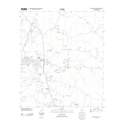
2012 Map of Gatesville East
USGS Topo · Published 2012About this map
Leon River meanders across this Central Texas landscape, marking the southern edge of Gatesville's eastward expansion and the northern boundary of the Fort Hood Military Reservation. The map captures a transition from the structured residential grid of East Gatesville into the smaller incorporated settlements of South Mountain and Fort Gates. Genealogists will find a high density of burial sites including Odd Fellows Cem, Restland Cem, and several smaller rural plots like Coryell Valley Cem and Greenbriar Cem. Transportation patterns are anchored by the river and the Longhorn Auxiliary Landing Strip, which sits just north of the military boundary. Creeks such as Stillhouse Br and Coryell Cr cut through the terrain, illustrating the drainage network that defines the region's physical geography.
Find a feature on this map
148 named features on this map. Tap any name to fly to it.
Don’t see what you’re looking for? This feature index may not catch every label — zoom into the map to look around manually.
Map Details
Editions of this 2012 Gatesville East Map
This is the sole edition of this map. No revisions or reprints were ever made.
Other maps of this area

1888 · Meridian
USGS Topo · 1:125,000

1894 · Meridian
USGS Topo · 1:125,000

1894 · Gatesville
USGS Topo · 1:125,000

1947 · Purmela
USGS Topo · 1:62,500

1947 · Oglesby
USGS Topo · 1:24,000

1947 · Gatesville West
USGS Topo · 1:24,000
1947 · Leon Junction
USGS Topo · 1:24,000

1947 · North Fort Hood
USGS Topo · 1:24,000

1947 · Gatesville East
USGS Topo · 1:24,000

1947 · Shell Mountains
USGS Topo · 1:24,000