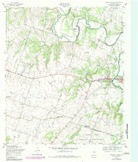
1954 Map of Gatesville West
USGS Topo · Published 1984About this map
Gatesville sits at the eastern edge of this Central Texas landscape, where the meandering Leon River defines the river valley. The map documents a significant military and institutional presence, with the sprawling Fort Hood Military Reservation occupying the southern terrain and the State Reform School Grounds located near the river bend north of town. Rural life and early development are evident in the scatter of small community centers like Bethel Heights and the presence of several country houses of worship, including Standlee Chapel and Keener Chapel. Transportation history is visible through an Old Railroad Grade and the City-County Airport. The topography is marked by distinctive elevations such as Bald Knob, while local genealogy is rooted in sites like Hemmeline Cem and Hay Valley Ch.
Find a feature on this map
21 named features on this map. Tap any name to fly to it.
Don’t see what you’re looking for? This feature index may not catch every label — zoom into the map to look around manually.
Map Details
Editions of this 1954 Gatesville West Map
This is the sole edition of this map. No revisions or reprints were ever made.
Other maps of this area

1888 · Meridian
USGS Topo · 1:125,000

1894 · Meridian
USGS Topo · 1:125,000

1894 · Gatesville
USGS Topo · 1:125,000

1947 · Purmela
USGS Topo · 1:62,500

1947 · Gatesville West
USGS Topo · 1:24,000

1947 · Pidcoke
USGS Topo · 1:24,000

1947 · North Fort Hood
USGS Topo · 1:24,000

1947 · Purmela
USGS Topo · 1:24,000

1947 · Gatesville East
USGS Topo · 1:24,000

1947 · Shell Mountains
USGS Topo · 1:24,000